aPPLICATION
/ Reservoir Evaluation
/ Geosteering
/ Hazard Avoidance
TECHNOLOGY
/ Logging While Drilling (LWD)
/ Wave Propogation Resistivity (WPR)
/ Universal Pressure Tool (UPT)
/ Measurement While Drilling (MWD)
/ Falcon X MP MWD
LOCATION
/ Permian Basin, USA
DOWNLOAD CASE HISTORY
/ PDF File
CHALLENGE
An operator in the Permian Basin sought to evaluate the production potential of the Barnett Shale across underdeveloped acreage. With limited offset data and uncertainty around subsurface conditions, the project required precise well placement and real-time reservoir insights without compromising drilling efficiency.
With limited production history in the target interval, the operator faced significant uncertainty regarding reservoir quality and geologic risk. At the same time, potential geomechanical hazards increased the need for precise well placement and real-time formation evaluation. Traditionally, achieving this level of subsurface insight would require additional LWD runs, introducing costly trips, increased rig time, and operational inefficiencies. The operator needed a solution that could deliver deeper reservoir insight for better decisions, reduce drilling risk, and enable safer, more efficient operations, without adding complexity or time.
SOLUTION
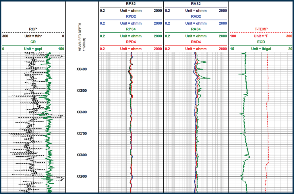
Scientific Drilling deployed an integrated MWD/LWD system, incorporating its dual-frequency Wave Propagation Resistivity (WPR) tool, proprietary dual PWD (AP/PP) measurement in the Universal Pressure Tool (UPT) for ECD monitoring, and latest high-speed Falcon X mud pulse MWD system. This solution provided continuous, real-time formation evaluation through the curve and lateral sections, eliminating the need for additional trips.
The geosteering team received reliable data transmission under extended-reach conditions, enabling them to accurately correlate formation markers, monitor downhole conditions, and proactively manage drilling risks in a single run.
RESULT
The operator completed two wells, each with two-mile lateral sections, using a 7.875” bit. The MWD/LWD system provided the geosteering team with real-time shallow and deep Resistivity measurements, total Gamma Ray, and ECD data, even through a maximum dogleg of 18.88°/100′. Project goals of reservoir evaluation and geomechanical hazard avoidance were achieved, and because SDI’s solution did not require a trip to incorporate the MWD/LWD system, the operator saved an estimated 14 hours of rig time based on local trip time averages.
YOU MAY ALSO BE INTERESTED IN
Efficient Pipe Recovery Operation in Geothermal Well 
