Advanced Formation Evaluation
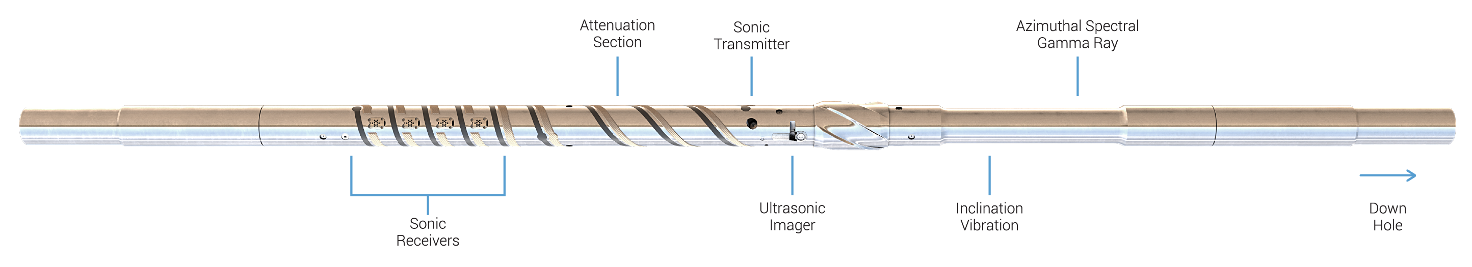
Scientific Drilling’s new Unconventional Logging Tool (ULT) is a compact, integrated LWD system. Therefore, it encompasses three principal services. The service optimizes for logging unconventional reservoirs and the benefits of geosteering. The ULT offers a cost-effective solution for intelligent completion designs. Above all, to improve production and optimize costs.
Most importantly, all three ULT sensors provide azimuthal data while rotating. Meanwhile, a 3-dimensional model of the reservoir can be built with the Logging While Drilling data. Compared to other service companies, the integrated sensor design shortens the tool length to 15’ and reduces the LIH cost. Thus, providing similar measurements with independent collar designs.
The ULT’s innovative design is industry-first. Which proves Scientific Drilling’s continued commitment to developing new technologies. To optimize further the drilling, evaluation, and development of resources.
AZIMUTHAL SPECTRAL GAMMA RAY
MEASUREMENTS
+ High-precision total gamma ray
+ Potassium, Uranium, and Thorium (K, U, Th) concentrations
+ 32-sector azimuthal gamma ray image
ULTRASONIC BOREHOLE IMAGER
MEASUREMENTS
+ High-resolution amplitude and travel time images
+ Borehole caliper image
+ Independent mud slowness measurement
AZIMUTHAL SONIC
MEASUREMENTS
+ Azimuthally focused unipole transmitter with a full-waveform receiver array
+ Conventional compressional and shear slowness (DTC, DTS)
DELIVERING THE ULTIMATE VALUE
/ Reducing Geosteering uncertainty
/ Improve petrophysical interpretations
/ Characterize the reservoir fracture network
/ Develop engineered completions strategies
/ Eliminate time-consuming wireline runs
TARGET APPLICATIONS
- Geosteering
- Intelligent Completion Design
- Petrophysical TOC evaluation
- Clay content determination
- Natural, drilling-induced, and hydraulic open fractures
- Min/max stress directions from fracture placement
- Accurate formation dip interpretation
- 360-degree borehole caliper
- Formation mechanical properties
- Sourceless, porosity-based, geosteering from real-time up/down DTC measurements
