APPLICATION
/ Geomechanical Evaluation
/ Cement Volume Calculation
/ Completion Optimization
/ Geosteering
TECHNOLOGY
/ Unconventional Logging Tool (ULT)
LOCATION
Marcellus Shale, Northeastern US
DOWNLOAD CASE HISTORY
/ PDF File
CLIENT CHALLENGE
An operator in the Northeast was planning to drill numerous wells with measured depths over 30,000ft. To prepare for these wells with superlaterals, a completion study was done to analyze effects of poor zonal isolation of the target formation during hydraulic fracturing operations. Previous offset wells had encountered problems getting cement to surface when running their production string. Accurate caliper information was needed to ensure that their cement volumes were correct for the upcoming 30,000ft MD wells.
SCIENTIFIC SOLUTION
Scientific Drilling’s Unconventional Logging Tool (ULT) employs an integrated design of LWD sensors optimized for the evaluation of shale reservoirs. ULT’s ultrasonic imager is capable of providing a 360º view of the borehole shape and size. This unique LWD tool was deployed in the client’s drilling BHA (which also utilized a rotary steerable system) in order to obtain caliper information while drilling and while tripping out-of-hole after reaching TD.
CLIENT VALUE
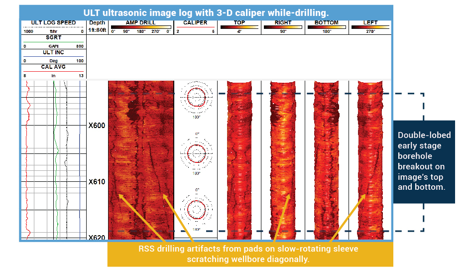
Since the drilling BHA also utilized a rotary steerable system, the borehole size was measured to be fairly in-gauge while drilling. Due to the bit-to-sensor offset of the ULT tool, the formation exposure time (FET) was ~20min while-drilling. After reaching TD, the BHA was back-reamed out for the ULT to additionally measure the same hole section logged while-drilling for comparison. Towards the heel of the lateral, FET was ~2 days and showed the highest percentage of borehole enlargement. The ULT caliper showed the over-gauged hole was primarily due to borehole breakout on the upper and lower quadrants of the wellbore.
The dataset from the ULT provided the client with valuable information in regards to the tectonic stresses in the area and the specific stratigraphic intervals of their target which were more susceptible to enlargement from the stress-induced breakout.
YOU MAY ALSO BE INTERESTED IN
SDI’s Gyro Batch Surveys Offer Significant Time and Cost Savings